Seonyudo Coastal Trail, Walk Korea’s West Sea Islands by Bridge
Contents
- Quick take
- What kind of walk the Seonyudo coastal trail is
- How to reach the Seonyudo coastal trail, with or without a car
- Walking the Seonyudo coastal trail section by section
- The Seonyudo coastal trail at a glance
- Best photo spots and when to go
- West Sea seafood on the island, and a few cautions
- Things to check before you go
- Wrapping up
Quick take
- About 40 to 50 minutes by car from Gunsan’s inner harbor, across the Saemangeum seawall and the Gogunsan Bridge, Seonyudo (선유도) is a West Sea island you can reach and walk without ever boarding a ferry.
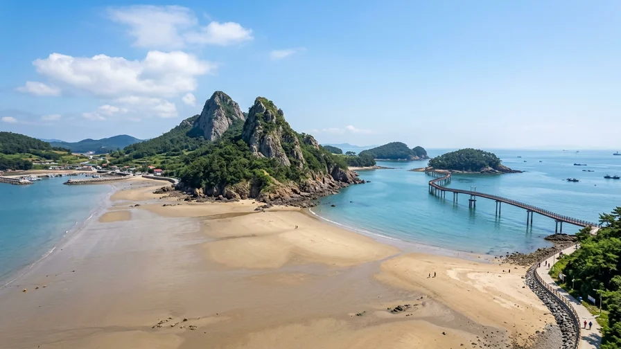
- The high points of the Seonyudo coastal trail are the Myeongsasimni sand flats that appear at low tide, the twin rocky peaks of Mangjubong, and the pedestrian bridges that link island to island at Jangjagyo and Daejanggyo.
- Without a car, bus 99 from Gunsan Intercity Bus Terminal runs all the way onto the island, and because the ground is mostly flat you can cover the core loop comfortably in three to four hours.
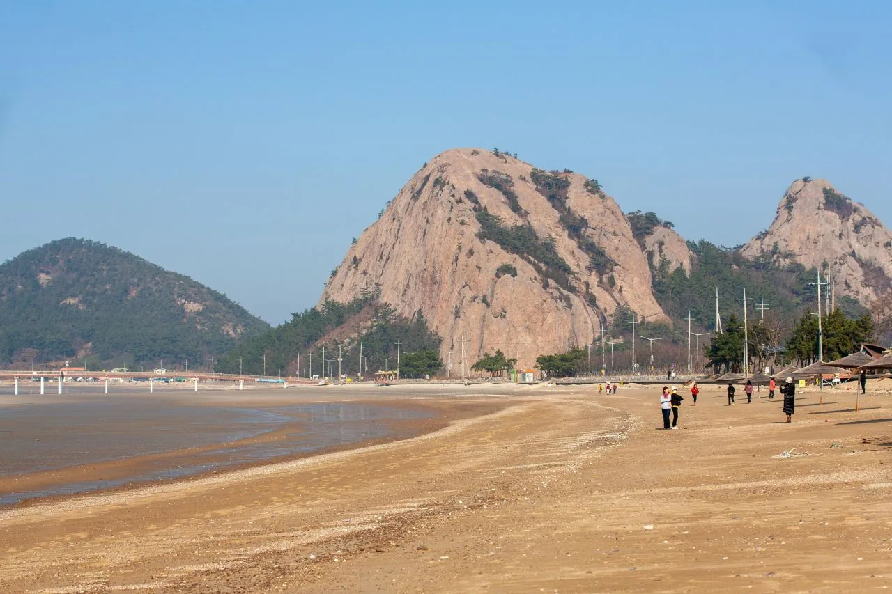
Stand on Myeongsasimni (명사십리) beach at the right tide and a sandbar several hundred meters wide opens out toward the sea. The sand is firm enough that your feet don’t sink, a zip-line cable crosses overhead like a small plane coming in to land, and behind you two rock peaks rise side by side at Mangjubong, looking down over the whole island. The Seonyudo coastal trail walks you through these scenes one by one. What sets it apart from other West Sea island hikes is simple: no ferry timetable to chase. You drive across the Saemangeum seawall and the Gogunsan Bridge straight onto the island, then start walking.
What kind of walk the Seonyudo coastal trail is
Seonyudo is the central island of the Gogunsan Archipelago (고군산군도), in Okdo-myeon, Gunsan, North Jeolla Province. The archipelago is a cluster of around 60 islands and islets — Seonyudo plus Munyeodo, Jangjado, Daejangdo, Sinsido and more — and several of them are joined by road and footbridge. Because of that, the Seonyudo coastal trail isn’t a single-island loop. Most people walk it as a chain that crosses on foot to Jangjado and Daejangdo, linking four islands in one outing.
The path itself is gentle. Apart from Mangjubong, which tops out around 100 meters, most of the route follows the coast on flat ground and easy boardwalk, so you don’t need hiking boots — a pair of trainers with a solid sole is enough. For the core loop alone, from the Seonyudo ferry pier out past Myeongsasimni, below Mangjubong, across the Seonyu Bridge to Jangjado and Daejangdo and back, you’re looking at roughly 8 to 10 km round trip. With breaks and photo stops that’s a relaxed three to four hours. You can also rent a bike or an electric scooter and shorten it.
There aren’t many large convenience stores or big shops on the island. Restaurants, cafes and small snack stalls cluster around the pier and along the Myeongsasimni shop strip, so it’s safer to grab water and a snack here before you set off. Once you head over toward Jangjado and Daejangdo the gaps between shops widen, so carry at least 500 ml of water per person from the start.
How to reach the Seonyudo coastal trail, with or without a car
Coming from Seoul, you first need to get to Gunsan. The KORAIL Janghang Line train from Yongsan Station to Gunsan Station takes about three hours, or an express bus from Seoul Express Bus Terminal (Central City) runs roughly 2 hours 40 minutes to 3 hours. Fares and timetables change, so check in advance on the official KORAIL site at letskorail.com. (verified October 2026)
Without a car: taking a Gunsan city bus to Seonyudo
From central Gunsan to Seonyudo, city bus 99 crosses the Saemangeum seawall and the Gogunsan Bridge and drives right onto the island. You can board near Gunsan Intercity Bus Terminal and near Gunsan Station, and the one-way ride to Seonyudo takes about 1 hour 10 minutes to 1 hour 30 minutes. There are only a few departures a day, so if you miss the first bus the wait for the next one is long. For the exact live times, search “Gunsan Intercity Bus Terminal → Seonyudo” in Naver Map and it shows that day’s bus 99 departures and ride time. The fare by transit card is a few thousand won for an adult (distance-based, subject to change), and both prepaid and postpaid transit cards work.
The bus drops you at the Seonyudo pier or a stop near Myeongsasimni, so you step off right at the trailhead. Confirm the last return bus time with the driver when you get off, or re-check it in Naver Map — if you miss the last bus from the island, getting back to the city the same day becomes difficult.
By car: across the Saemangeum seawall and the Gogunsan Bridge
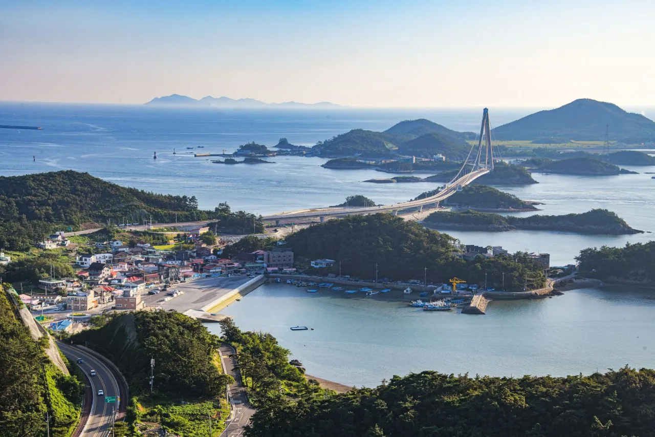
By private car or rental, you pass the Saemangeum seawall (about 33 km, one of the longest seawalls in the world), go through Sinsido and Munyeodo, cross the Gogunsan Bridge, and arrive right at the Seonyudo parking area. It’s about 40 to 50 minutes from central Gunsan. On weekends and in peak season the public lots near the Seonyudo pier and Myeongsasimni fill up fast, so arriving early in the morning makes parking much easier.
Getting around
If you’re a foreign visitor renting a car, you must have an International Driving Permit (IDP), and it can’t be issued after you arrive in Korea — get it in your home country before you travel. The Kakao T taxi app often requires a Korean phone number and a domestically issued card to register and pay, which makes it hard for short-stay visitors. A taxi from the rank at Gunsan Station or the terminal, paired with Google Maps for navigation, is the safer bet. Seonyudo is an outlying island where flagging a taxi on the spot is tough, so if you’re on foot, the key is to plan your route around the bus times.
Walking the Seonyudo coastal trail section by section
Break the Seonyudo coastal trail into four scenes and you won’t lose your way. Start at the pier and Myeongsasimni, pass below Mangjubong, cross the Seonyu Bridge to Jangjado and Daejangdo, then return the same way. That out-and-back loop is the easiest option for a first visit.
Section 1: Myeongsasimni beach
Seonyudo’s signature is Myeongsasimni (명사십리) beach. It’s wide and shallow-sloped, so at low tide the sea pulls far back and a huge sand flat appears. The sand is fine enough to walk barefoot, and at the end of the beach the zip-line (Seonyudo Zipwire) flies over Myeongsasimni toward the far shore. Operation, pricing and weight limits change with the weather, so check the day’s status at the on-site ticket booth or on Google Maps.
Section 2: Mangjubong and Seonyudo beach
Inland from Myeongsasimni, the two rock peaks of Mangjubong stand side by side like the island’s emblem. After rain, several streams run down the cliff faces to create what locals call “Mangju Falls.” The climb to the top is short but steep, with mixed rock sections, so if you’re unsure about your fitness or footwear, looking up at it from below is plenty. From the summit you can take in the islands of the Gogunsan Archipelago scattered across the sea in a single sweep.
Section 3: Seonyu Bridge and Jangjado
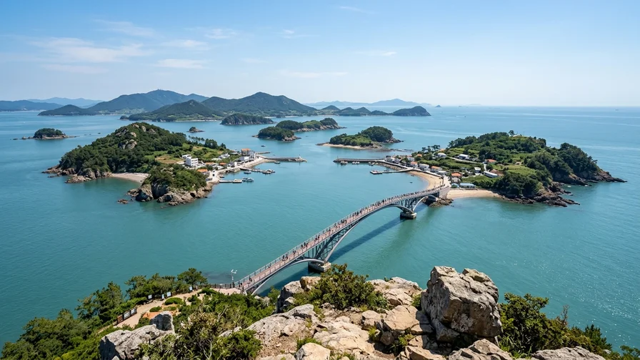
Seonyudo and Jangjado are joined by a pedestrian span called the Seonyu Bridge. Walking across it, with sea and fish farms opening out on both sides, is the most open-feeling stretch of the trail. Cross over and you reach Jangjado (장자도), a small fishing village island where seafood restaurants and cafes gather around the pier.
Section 4: Daejangdo and Daejangbong
Cross another bridge from Jangjado and you arrive at Daejangdo (대장도). Its peak, Daejangbong (about 142 m), is widely rated the best viewpoint on the whole trail. From the “Halmae Rock” (Grandmother Rock) lookout near the top, the full panorama of the Gogunsan Archipelago — Seonyudo, Jangjado and Munyeodo linked by bridges — spreads out below your feet. It’s a short detour of around an hour round trip, but the final push is fairly steep, so take it slow.
The Seonyudo coastal trail at a glance
| Section | What stands out | Round trip |
|---|---|---|
| Myeongsasimni | Wide sand flats, zip-line | 30–40 min |
| Mangjubong | Twin-peak views, steep | About 1 hr |
| Seonyu Bridge and Jangjado | Footbridge, sea views | 40 min–1 hr |
| Daejangbong (Daejangdo) | Best lookout | About 1 hr |
The times in the table are averages that include photo stops and rests; your pace and the crowds on the day will shift them. (verified October 2026)
Best photo spots and when to go
The shots people take most on the Seonyudo coastal trail are fairly set. If it’s your first time, work these four into your route and you’ll rarely come away disappointed.
- Stand at the far end of the Myeongsasimni sand flat and frame Mangjubong behind, and the beach and the twin peaks sit in one shot. The sand is widest at low tide, so check a tide table beforehand and aim for the hours around low water.
- From the midpoint of the Seonyu Bridge, looking toward Jangjado, the railing and the sea line up in a long straight composition.
- The Halmae Rock lookout on Daejangbong is the single best point for capturing the whole Gogunsan Archipelago, with the bridge-linked islands all in one frame.
- Around sunset, the western sky over Myeongsasimni glows with the deep red the West Sea is known for. Sunset times shift by season, so check the day’s sunset and be in position about 30 minutes before.
For timing, early morning and late afternoon are best. In the middle of the day there’s almost no shade on the sand or the boardwalk, and in summer your body heat climbs quickly. If you’re on foot, come in on a morning bus, see Myeongsasimni and Mangjubong, loop Jangjado and Daejangdo, then leave on a late-afternoon bus — the light is better and you dodge the crowds.
West Sea seafood on the island, and a few cautions
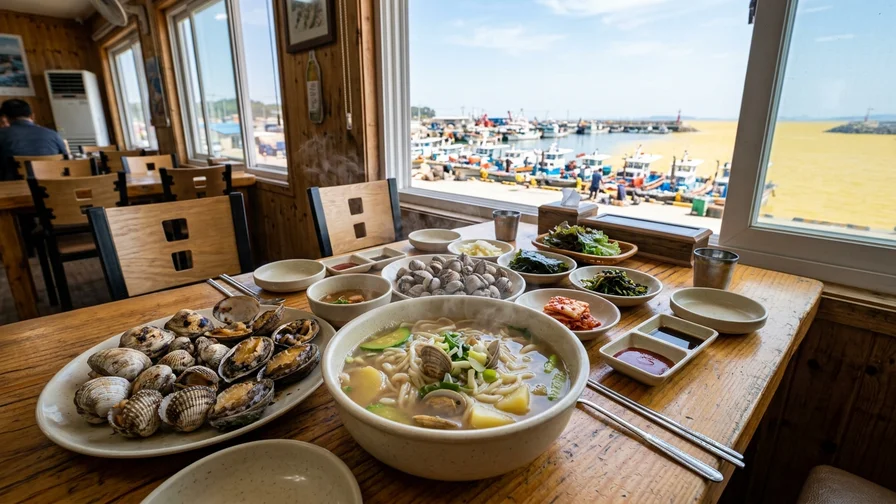
Around the piers at Seonyudo and Jangjado you’ll find West Sea seafood restaurants serving bajirak kalguksu (clam knife-cut noodle soup), blue crab stew, clam rice porridge and raw-fish cold soup. The one most worth trying is bajirak kalguksu — a clear, bracing noodle soup made with the manila clams that are plentiful along the West Sea. There are also seasonal windows, like spring webfoot octopus or autumn blue crab, but wild seafood supply swings with the weather and the tides, so if you’re after a specific dish, call ahead or check Google Maps the day you go.
Traditional fishing-village restaurants and harborside stalls often don’t take cards — many are cash only or ask for a bank transfer. ATMs are scarce on the island, so bring cash. Many places have no English menu, so ordering from the menu photos on Google Maps or using a translation app makes it much smoother.
A note for readers with seafood allergies. Among clams, blue crab and shrimp, crab and shrimp are crustaceans, while clams, mussels and oysters are mollusks (shellfish) — different allergens. A crustacean allergy doesn’t automatically mean you have to avoid mollusks, and vice versa, so know your own allergen and order accordingly. Because everything is cooked in the same kitchen, mention it in advance if you’re sensitive to cross-contamination.
Korean to use at the restaurant
bajirak kalguksu (바지락칼국수) / kkotge-tang (꽃게탕, blue crab stew)
“Bajirak kalguksu i-in-bun juseyo.” (Two servings of clam noodle soup, please.) / “Hyeongeum-man doe-nayo?” (Cash only?) / “Sajin menu innayo?” (Do you have a photo menu?)
Things to check before you go
You can walk the Seonyudo coastal trail year-round, but the prep changes with the season and the weather. Summer has little shade, so a hat, sunscreen and plenty of water are essential. In winter and early spring the West Sea wind blows hard and the feels-like temperature drops a lot, so pack a windproof jacket. On windy days, experiences like the zip-line may stop running.
Tides matter too. The Myeongsasimni sand flat is widest at low tide, so lining up both your walk and your photos with low water pays off. You can check tide tables for the Gunsan or Gogunsan area through official sources such as the Korea Hydrographic and Oceanographic Agency.
Parking is the biggest wildcard on peak-season weekends. The lots near Myeongsasimni and the pier often fill by late morning, so if you’re driving, arrive early. On foot, as noted above, check bus 99’s times for that day in Naver Map and make a note of the last departure.
If you want to buy island seafood or dried fish as a souvenir, remember that most countries treat fresh seafood as subject to quarantine on entry. To take something home, choose shelf-stable dried or processed products that are more likely to clear customs, and check your home country’s customs rules in advance for the exact conditions.
Wrapping up
The Seonyudo coastal trail is an easy entry point for both car-free travelers and drivers, precisely because you cross bridges and walk the West Sea islands without a ferry. The wide sands of Myeongsasimni, the twin peaks of Mangjubong, and bridge-linked Jangjado and Daejangdo all fit into a half-day loop. Before you set off, save that day’s bus 99 schedule, the tide table and the sunset time to your map, and check the local weather.
Some photos © Korea Tourism Organization (KOGL Type 1)